

Where do tropical storms typically form in the Atlantic? Month-by-month breakdown

Tropical update: July 9, 2025
FOX 35 Meteorologist Laurel Blanchard has the latest conditions in the tropics. The 2025 Atlantic Hurricane Season runs July 1 - November 30. Download the FOX Local app for tropical alerts and notifications.
ORLANDO, Fla. - As meteorologists, one of the keys to tracking tropical storms is knowing where to look—depending on the time of year. The Atlantic hurricane season doesn’t behave the same from start to finish. Instead, different regions of the ocean become more (or less) favorable for storm formation as the months go by.
That’s because the ingredients for tropical development, like warm sea surface temperatures, low wind shear, and moist, dust-free air—don’t show up all at once. The ocean takes time to heat up, and atmospheric patterns shift with the seasons. So each month, we adjust our focus: from the Gulf and western Caribbean early in the season, to the vast open Atlantic by late summer, then back closer to land in the fall.
Understanding these evolving patterns helps us spot trouble early—and give you the earliest possible heads-up.
June:
Hurricane season officially starts in June, but it’s usually a slow start. This year is no different. Even though the sun is highest in the sky this month, the ocean doesn’t heat up instantly. Water warms slowly, so peak ocean temperatures lag a couple of months behind—just like how summer heat lingers even after the longest day of the year.
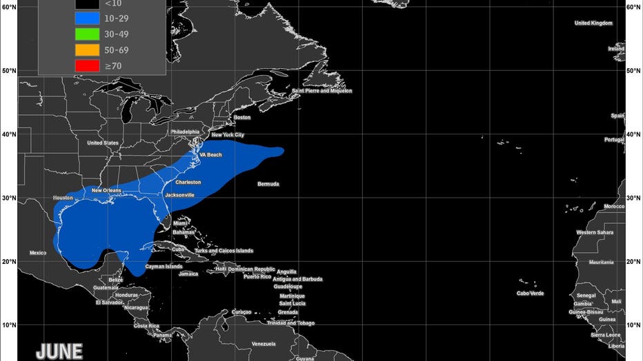
As a result, only the Gulf, western Caribbean, and areas near the Southeast U.S. are warm enough to support storms. Even then, high-altitude winds and dry air often keep systems from growing too strong. We can get "home-grown" systems in the early season period, often developing right in our backyard.
July:
By July, ocean temperatures are climbing, and wind conditions begin to improve. Storms are more likely to form in the Caribbean and off the U.S. East Coast. Some waves coming off Africa even start to show potential, though it's still early in the season for these "Cape Verde" type systems making the long trek across the Atlantic, due to cooler ocean temps, higher levels of wind shear and Saharan dust.
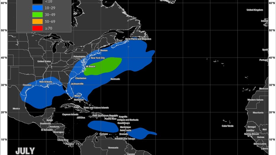
That dust continues to dry the air and blocks storms from really taking off. It’s a transition month—things are ramping up, but not quite there yet.
August:
This is when the season kicks into high gear. Thanks to that delayed ocean warming, sea surface temperatures are now hot enough almost everywhere—from the Gulf to the open Atlantic. Wind shear drops and Saharan dust settles down.
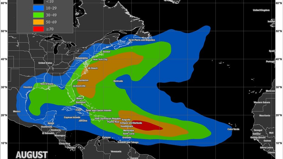
Storms can now form far from land and travel thousands of miles, often growing into hurricanes. August is prime time for long-tracked storms that start near Africa and head west.
September:
Everything peaks in September. September 10th is the date we see our highest frequency of systems. Oceans are at their warmest, the atmosphere is stable enough to let storms grow, and the skies are usually clear of Saharan dust.
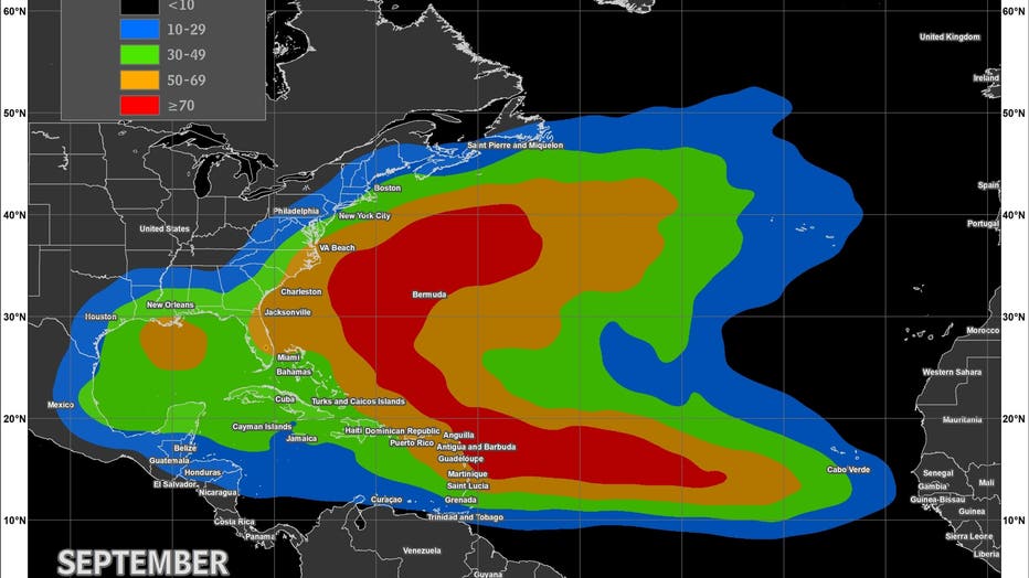
The Main Development Region—the belt of ocean between Africa and the Caribbean—is especially active as vigorous tropical waves emerge from equatorial Africa into the Atlantic at regular intervals, sometimes multiple times per week. It’s the perfect setup for big, long-lasting hurricanes. This is the busiest—and often most dangerous—month of the season.
October:
By October, the central Atlantic starts cooling off, but the Gulf and western Caribbean stay plenty warm, thanks to the lingering summer heat stored in the water. That’s where storms now prefer to form. They often spin up from leftover cold fronts or tropical waves that get a late-season boost from still-warm waters.
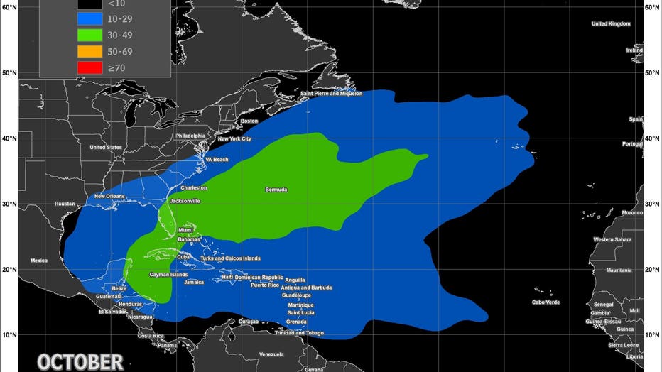
This is also a time when "home-grown systems" can spin up, and they can be especially dangerous for Florida as they can come in from the Gulf as major hurricanes. The largest hurricane on record to hit Tampa was in October 1921. More recently, Hurricane Milton slammed the Gulf Coast in early October 2024.
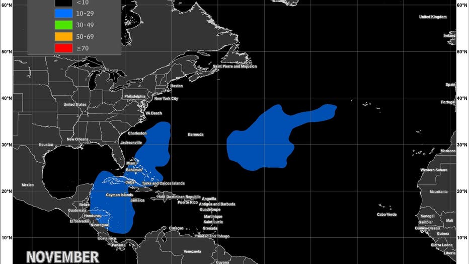
November:
As we head into November, cooler air and stronger winds across the Atlantic put a lid on storm development almost everywhere—except for the far western Caribbean, where warm waters persist just a little longer. Storms are rare this late, but they can still happen, especially in that last warm pocket of ocean.
Of course, not every season follows the rules exactly. Sometimes the ocean gets warmer or cooler in strange places, or the winds blow in different ways. These changes can make the storms show up at different times or in new places, which makes each season a little different from the last.
The Source: The information in this article comes from NOAA and FOX 35 Storm Team Meteorologist Brooks Garner.