Tropical Storm Idalia: Florida communities reeling from Category 3 storm aftermath
Tracking Idalia - Stream FOX 35 News
ORLANDO, Fla. - Tropical Storm Idalia made landfall Wednesday morning. Follow along for the latest updates as they come in.
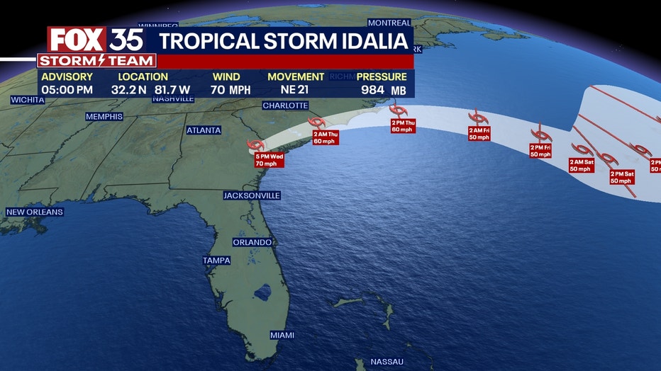
5 p.m. National Hurricane Center update
Hurricane Idalia has been downgraded to Tropical Storm Idalia.

3 p.m.: DeSantis denounces looting during Perry press conference
At a press conference in Perry, Florida, on Wednesday afternoon, Florida Gov. Ron DeSantis said there have been reports of looting in storm-impacted areas after Hurricane Idalia.
"There are reports of people trying to loot down in Steinhatchee," he said. "I've told all our personnel at the state level, ‘You protect people’s property and we are not going to tolerate any looting in the aftermath of a natural disaster.' I mean it's just ridiculous that you would try to do something like that on the heels of an almost Category 4 hurricane hitting this community."
DeSantis also reminded looters that this part of the state is riddled with "advocates and proponents of the Second Amendment."
"I've seen signs in different people's yards in the past after these disasters … ‘You loot, we shoot.’ You never know what's behind that door," DeSantis said. "If you go break into somebody's house and you try to loot, these are people that are going to be able to defend themselves and their families.
"I would not do it. We're going to hold you accountable from a law enforcement perspective at a minimum and it could even be worse than that depending on what's behind that door. So let's band together and life people up and not try to take advantage of a difficult situation."
12:32 p.m. Hurricane Idalia leaves Florida
Governor Ron DeSantis held a press conference and announced that Hurricane Idalia left Florida. Although Idalia has made its way out of the state, many areas are still dealing with flooding and the aftereffects of the hurricane.
9:35 a.m. update: Catastrophic storm surge
The eye of Hurricane Idalia is moving just inland from the Florida Big Bend Coast, creating catastrophic storm urge and damaging hurricane-force winds continue.
7:45 a.m. update: Hurricane Idalia makes landfall near Keaton Beach
Hurricane Idalia made landfall in the Big Bend region near Keaton Beach at 7:45 a.m. Wednesday, according to the National Hurricane Center.
Idalia made landfall as a Category 3 storm with maximum sustained winds of 125 mph.
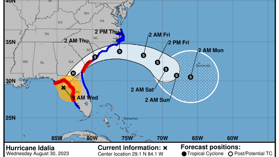
The storm is expected to weaken after landfall, but is forecast to maintain hurricane status as it moves across southern Georgia and near the coast of Georgia or southern South Carolina later on Wednesday. Idalia is forecast to move off the southeastern U.S. coast early on Thursday and most eastward into the rest of the week and into the weekend.
CONTINUING COVERAGE
- When could my power go out?
- Orlando International Airport updates
- School closures
- Storm shelters
- Emergency resources
- Live webcams
7 a.m. update: Has Hurricane Idalia made landfall yet?
Hurricane Idalia is now again a strong Category 3 storm with maximum sustained winds of 125 mph, according to the National Hurricane Center. It's located 55 miles northwest of Cedar Key and 65 mph south-southeast of Tallahassee. The storm is moving north-northeast at 18 mph.
A Category 3 storm has maximum sustained winds of 111-129 mph. A Category 4 has winds of 130-156 mph.
6:10 a.m.: Hurricane Idalia nears landfall, residents urged to take shelter
The National Weather Service office in Tallahassee issued an update around 6 a.m. Wednesday urging residents along the coast of Taylor and Dixie counties to take immediate shelter. Hurricane Idalia's eyewall is expected to come onshore in the next hour or two.
"THIS IS AN EXTREMELY DANGEROUS AND LIFE THREATENING SITUATION!"
5 a.m. Hurricane Idalia advisory
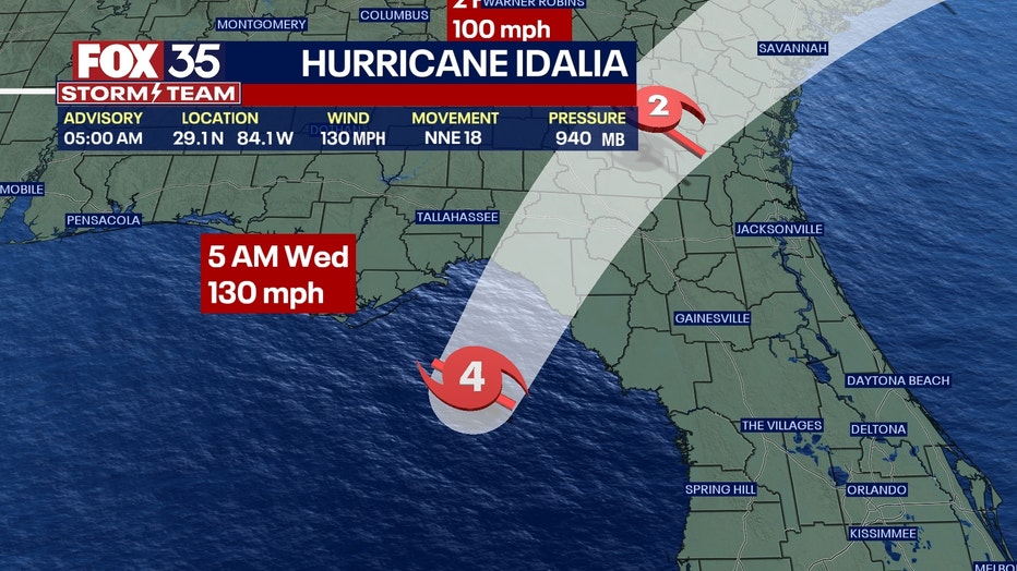
5AM: Idalia strengthens, becomes Cat. 4 hurricane
Hurricane Idalia is making its way toward Florida on Wednesday morning, and is expected to continue strengthening as it approaches the Gulf Coast. Follow along for the latest updates as they come in.
Hurricane Idalia is now an "extremely dangerous" Category 4 as it approaches the Gulf Coast of Florida near the Big Bend region, according to the National Hurricane Center.
Idalia has maximum sustained winds of 130 mph as it moves north at 18 mph. The NHC said Hurricane Idalia still has a few hours left to continue intensifying before it makes landfall.
Idalia is located about 60 miles southwest of Cedar Key and about 90 miles south of Tallahassee.

After making landfall, Idalia is expected to turn toward the northeast and east-northeast. The storm is expected to weaken after landfall, but still maintain hurricane status as it moves across southern Georgia, and even as it reaches the coast of Georgia or South Carolina later on Wednesday.
Idalia is expected to dump 4-8 inches of rain, with isolated maximum totals up to 12 inches from the Big Bend region through central Georgia and South Carolina. Tampa Bay could see up to 6 feet in storm surge.

Watches and warnings in effect
Treasure Island flooding during Idalia
The City of Treasure Island shared video on social media of flooding on Gulf Boulevard. Officials are urging residents to not drive through flooded roadways. (Video: @TresIslandFL/X)
Storm surge warning:
- Englewood northward to Indian Pass, including Tampa Bay
- St. Catherine's Sound to South Santee River
Hurricane warning:
- Middle of Longboat Key northward to Indian Pass, including Tampa Bay
- East of Altamaha Sound, Georgia, to Edisto Beach, South Carolina
Tropical storm warning:
- Chokoloskee northward to middle of Longboat Key
- West of Indian Pass to Mexico Beach
- Sebastian Inlet to Surf City, North Carolina
- North of Surf City, North Carolina to North Carolina/Virginia Border
- Palmlico and Albemarle Sounds
Storm surge watch:
- Bonita Beach northward to Englewood, including Charlotte Harbor
- Mouth of St. Mary's River to South Santee River, South Carolina
- Beaufort Inlet to Drum Inlet, North Carolina
Hurricane watch:
- Mouth of St. Mary's River to Edisto Beach, South Carolina
Tropical storm watch:
- North of Surf City, North Carolina, to the North Carolina/Virginia border
- Pemlico and Albemarle Sounds

5 a.m.: Extreme wind warning for Southeast Big Bend
115+ mph sustained winds with eyewall are likely in the Southeast Big Bend region over the next two hours.
4:34 a.m.: Tornado warnings in effect across several Central Florida counties
At 4:34 a.m., a severe thunderstorm capable of producing a tornado was located 7 miles northeast of Wauchula, moving northeast at 35 mph.
At 4:34 a.m., a severe thunderstorm capable of producing a tornado was located over Bithlo, moving north at 40 mph.
A tornado warning has been issued for southeastern Seminole County and east central Orange County until 5 a.m.
4:28 a.m.: Tornado warnings continue across Central Florida
A tornado warning has been issued for southeast Citrus County, west central Sumter County and central Hernando County until 5 a.m.
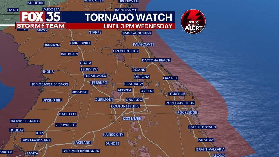
A tornado watch initially including Lake County has been extended to include Osceola, Orange, Volusia and Seminole Counties through 6 a.m.
4:20 a.m.: Tornado warnings continue in Osceola, Orange County
A tornado warning continues for Bithlo, Wedgefield and Lake Mary Jane.
4:07 a.m.: Tornado warnings issued in Osceola, Orange county
A tornado warning has been issued for Osceola and Orange counties, including Saint Cloud FL, Bithlo FL, and Wedgefield FL until 4:30 a.m.
DOWNLOAD THE FOX 35 STORM TEAM APP FOR THE LATEST UPDATES

