

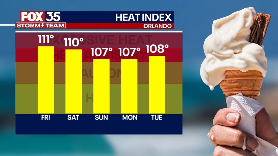
Orlando weather: Dangerously hot conditions continue as heat index soars to 110-115 degrees
ORLANDO, Fla. - Today's high: 98 degrees | Tonight's low: 80 degrees
Main weather concerns: Thursday has been declared a FOX 35 Weather Impact Day as heat and high humidity continue to dominate across Central Florida.
Hot afternoon highs are expected to hit the upper 90s again with heat index readings heading for the 107-115 degree range across the Orlando Metro and along the east coast beaches.
An Excessive Heat Warning has been issued until 7pm this evening. Rain chances stay very low today, meaning there will not be much relief from the heat. Coverage is at 30% and mainly for the Eastern Counties closer to the Atlantic.
Back to class: See county-by-county breakdown for first day of school
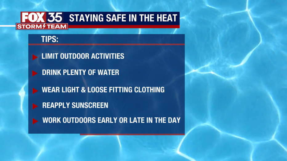
Staying safe in the heat
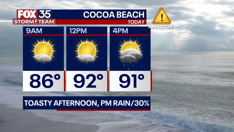
BEACHES: It will be hot at the beaches on this Thursday. Highs soar to the mid-90s with heat index values well into the triple digits. Rain and isolated storm chances remain at 30% coverage by mid-afternoon. Surf will range 1-2 feet with a moderate rip current risk. It's important to keep yourself cool and in the shade as much as you can.
THEME PARKS: Stay hydrated at the theme parks today. Forecast highs soar to near 98 with heat index values are expected to peak as high as 115 degrees.
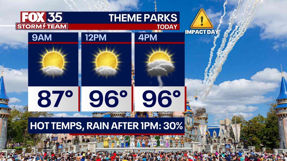
Rain chances are limited to 30% coverage today so there won't be much relief from the intense heat, take breaks inside the A/C when you can. Highest rain chances take shape after 2pm.
OUTLOOK: The FOX 35 STORM TEAM has declared the remainder of the week FOX 35 WEATHER IMPACT DAYS. Afternoon highs soar to the upper 90s with heat index readings in the 107-115 degree range. Today is the first day of school for most students across central Florida and it will be HOT.
Parents should consider the impacts it can bring to students heading back to the classroom. Bike riders and walkers should use caution and limit outdoor activities to 15 minute increments. The high heat will continue into the weekend with mid-upper 90s looking likely.
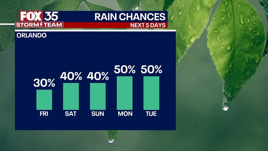
Rain chances will rise a bit by Saturday and Sunday. Expect coverage in the 40-50% during this time.
TRACKING THE TROPICS: The tropics remain quiet with Saharan dust keeping the tropics at bay for now. No tropical systems are expected in the next 7 days. The FOX 35 STORM TEAM will be tracking conditions for you and let you know if anything changes.